

Aerial Photogrammetry &
Construction Documentation
Track every stage of your project from the air — with regular aerial progress updates, precision photogrammetry mapping, and stunning end-of-project compilation videos that tell the complete story of your build.
Why Aerial Documentation Changes Everything
Construction projects are complex, expensive, and time-sensitive. Aerial photogrammetry and regular drone documentation give project owners, managers, contractors, and stakeholders an accurate, up-to-date view of every phase — from groundbreaking to ribbon-cutting.
Accurate Progress Tracking
Regular aerial flights create a precise, date-stamped visual record of exactly what has been completed — and what remains. Identify schedule slippage, material staging issues, and site organization problems before they become costly delays.
Precision Photogrammetry Mapping
Photogrammetry converts aerial imagery into accurate 2D orthomosaic maps and 3D models of your site — providing measurable data on earthwork volumes, grade progress, and site conditions without requiring boots on the ground.
Regular Update Flights
Scheduled weekly, bi-weekly, or monthly flights keep all stakeholders informed with current site imagery — dramatically reducing miscommunication between owners, architects, engineers, and contractors.
End-of-Project Compilations
When your project is complete, your entire documentation archive is compiled into a polished, professional timelapse video that showcases the full scope of the build — a powerful marketing and portfolio asset.
Legal & Insurance Documentation
Date-stamped aerial records provide indisputable visual evidence of site conditions at every stage — invaluable for resolving disputes, supporting insurance claims, and demonstrating contract compliance.
Stakeholder & Investor Reporting
Impress investors, lenders, government agencies, and clients with professional aerial progress reports that demonstrate accountability, professionalism, and forward momentum on their investment.
More Than Just Aerial Video
Photogrammetry is the science of extracting precise measurements and 3D data from overlapping aerial photographs. Using the DJI Matrice M30T and specialized processing software, Fly With Me can turn a single flight into a detailed, measurable 3D model of your entire construction site.
Unlike standard video, photogrammetry data can be used to calculate earthwork volumes, measure stockpiles, verify grade elevations, track cut-and-fill progress, and generate accurate as-built documentation — all without surveyors setting foot on potentially hazardous active construction sites.
Based in the Treasure Valley Region of Idaho, Fly With Me serves construction projects throughout Boise, Nampa, Caldwell, Meridian, Mountain Home, and the broader Southwest Idaho and Eastern Oregon area — bringing enterprise-grade aerial documentation capability to projects of all sizes.
Steve's 20 years in law enforcement and 17 years in emergency medicine built an exceptional ability to observe, document, and report accurately under demanding conditions — exactly the skills that make great construction documentation.
📐 Photogrammetry Deliverables
Regular Updates. Complete Record.
The real power of aerial construction documentation is not any single flight — it's the cumulative record that builds over the life of the project. Here's what a complete documentation program looks like.
Pre-Construction Baseline
A detailed aerial and photogrammetry survey of the site before any work begins — establishing the baseline for all future comparisons and providing a legal record of pre-existing site conditions.
Regular Progress Flights
Scheduled flights at agreed intervals — weekly, bi-weekly, or monthly — capture site progress with consistent coverage. Each flight adds to the archive and generates a progress report for stakeholders.
Milestone Documentation
Key project milestones — foundation pour, structural topping out, envelope completion, site paving — are documented with dedicated flights capturing each achievement in detail.
End-of-Project Compilation
When the project is complete, all footage is compiled into a polished timelapse and highlight reel — a powerful showcase video for your portfolio, investors, and future clients.
📈 Why Regular Updates Matter
Real Projects. Real Results.
These examples showcase Fly With Me aerial documentation work on actual projects in the Treasure Valley Region of Idaho and surrounding areas — from infrastructure to development to unique specialty projects.
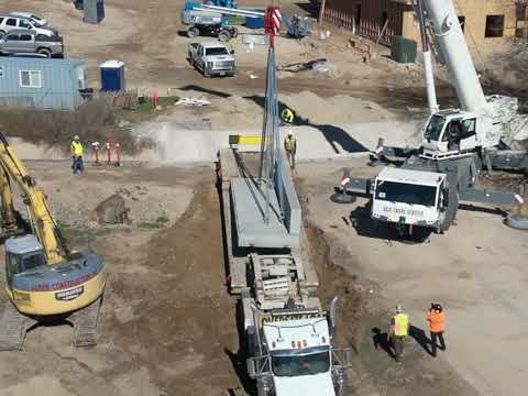
Caldwell Bridge
Aerial photogrammetry and progress documentation of the Caldwell Bridge construction project.
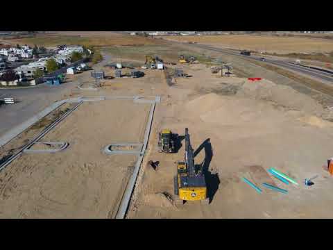
Canyon Springs RV Resort
Long-term aerial site monitoring and development documentation for Canyon Springs RV Resort.
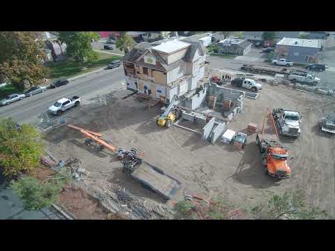
Rice House Relocation
Complete aerial documentation of the Rice House relocation project from start to finish.
More project examples on our YouTube channel
Measurable Value on Every Project
Aerial construction documentation delivers quantifiable value that goes far beyond simply having good photos of your project.
Your Complete Documentation Package
Every project documentation program includes a comprehensive set of deliverables that serve your operational, legal, marketing, and reporting needs.
Progress Videos
Professionally edited progress update videos after each flight — shareable with stakeholders, investors, and clients.
Orthomosaic Maps
Accurate, scaled 2D aerial maps of the site — suitable for CAD overlay, GIS integration, and planning documents.
3D Site Models
Detailed 3D point cloud models for volume calculations, grade verification, and as-built documentation.
High-Resolution Photos
Full-resolution aerial photographs from every flight — GPS-tagged and date-stamped for legal documentation.
Timelapse Compilation
A complete end-of-project timelapse video showing the entire build from first dirt to finished structure.
Progress Reports
Written summary reports with annotated imagery highlighting progress, concerns, and observations from each flight.
Built for Every Project Type
From residential developments to major infrastructure projects, Fly With Me provides professional aerial documentation for construction projects of all sizes throughout the Treasure Valley Region of Idaho and beyond.
Based in Caldwell, Idaho in the heart of the Treasure Valley Region — serving Boise, Nampa, Meridian, Mountain Home, Twin Falls, Baker City, and all points within a 250-mile radius.
How It Works
Setting up a construction documentation program is straightforward. We work around your project schedule and deliver results on a timeline that keeps your stakeholders informed.
Project Consultation
We discuss your project scope, timeline, flight frequency, and specific deliverable needs to build a custom documentation plan.
Baseline Survey
An initial pre-construction flight establishes the site baseline — documenting existing conditions before work begins.
Scheduled Progress Flights
Regular flights at agreed intervals keep the documentation current — each generating maps, models, photos, and a progress video.
Final Compilation
At project completion, the full archive is compiled into a polished timelapse and highlight reel ready for your portfolio and presentations.
Ready to Document Your Next Project?
Based in the Treasure Valley Region of Idaho — serving construction projects throughout Boise, Nampa, Caldwell, Meridian, Twin Falls, Baker City, and Southwest Idaho. Free quotes with no obligation.
Get Your Free Quote